The Land between Two ........
The Land Between Two Expressways
Date: 8th Jan. 2012
Distance: 7.6km
Date: 15th Jan. 2012
Distance: 10.6km
Date: 8th Jan. 2012
Distance: 7.6km
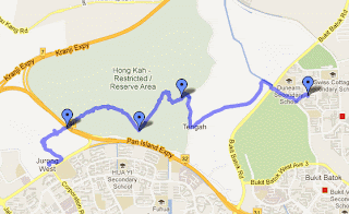
A hike from Boon Lay to Bukit Batok via Hong Kah. The third in a series of hikes in the Hong Kah area that i organized.
We took a bus from Boon Lay interchange to our start point outside Jurong Junior College. According to a 1978 topographical map of Singapore, the hill across the road from Jurong Junior College. Taking a trail leaving the abandoned Jurong road, we skirted about the hill and reached a canal. The canal lead to PIE. Like a previous trip, we crossed underneath the expressway using the drain. On the other side of PIE lies Hong Kah, and we continue for a while along the canal. Trees and shrubs lined the banks of the canal, as we slowly left behind the rumble of the mighty PIE. We turned onto what i believe to be Kian Hong Rd. This road is marked (though not named) on the 2010 topo map. The idea is to walk down this road till th end and make our way east towards Track 22. However, years of neglect has led the vegetation to reclaim this road. We follwed whats left of the road as far as we can go, and then crashed into pretty vegetation in search for an exit to Track 22. The going was tough, although its barely half a km. The trying part was a muddy stream that we spent quite a while fording, and many people got healthy doses of mud. After that, the rest of the hike was straightforward.
The Land Between Two Reservoirs
Distance: 10.6km
A hike from Upper Seletar Reservoir to the western edge of Upper Pierce Reservoir. The third in a series of hikes that i organize with variations on the theme of the Woodcutter's trail.
Most of us met up at Ang Mo Kio and took bus No. 138 to Upper Seletar Reservoir. Picking up a few more where we alight, eventually, a group of 26 proceeded into the trail. We took the trail that hugs the lakeshore, the trail is pleasant and offers fine vista of the lake (somehow calling it a reservoir diminishes its elegance). The lake shore trail proceeds into one of the 'fingers' of the lake. The opposite shore across the 'finger' overflowed with green, cast a peaceful reflection on the lake waters, and must be one of the prettiest sight on the island that morning.
The 'finger' narrows to it's tip, and we had to cross a muddy stream that lets into the lake. From there, it was pretty thick vegetation for a few hundred metres with no discernible trail before we finally made our way to the Woodcutter's trail proper. We didn't stay on the trail for long. Soon we branched into a trail that i suspect is actually the original Woodcutter's trail or some route that was once a proper route, as it is marked by well cut stone markers. In any case, the trail heading west eventually peters out and we were left to bushwhack through the vegetation. We crossed a small delightful stream, and eventually linked up with a open patch of ground, which functions as a emergency helipad. The regular trail thence leads to the serenely beautiful western edges of Upper Pierce Reservoir. Sitting below the levee that made the reservoir is a huge waterworks. I had intended to find a route of the far side of the waterworks that will lead us onto Chestnut Ave. That approach turned out to have to be too difficult, and in the process I had my pants seriously shredded beyond repair. I finally decided to turn back and headed out via the regular trail.
Overall, it is a very satisfying hike, and most people in the group seem to enjoy it.


Comments
Post a Comment