Town Hill, Bermuda. 79 m
 |
Summit of Town Hill. Capped with a tower dating from 1908 and a more modern radio tower attached to it.
|
Date Climbed: 3rd of Dec. 2018
Route: Flatts Village - The Peak Road
Start elevation: 2 m
Start elevation: 2 m
Elevation gain: +77 m
Town Hill is the highest point of the British Overseas Territory of Bermuda. At 79 m, it is also the highest geographical feature within a radius of 1000 km, as Atlantic Ocean surrounds it and the nearest landfall is North Carolinas.
Obtaining information on the routes up this summit is not straightforward. It seems that the hill is on private land, and The Peak Road, the road/track that leads up to the hill does not show up on Google map or any of the local maps that I came across. Finally after looking around, I found that peakbagger.com page for Town Hill has a ArcGIS-World Topo map that shows a series of roads around the summit area. Also, from this blog, I got to know that the summit of Town Hill, which was also known as "The Peak", is decorated with a tower that dates back to 1908, which is a useful marker to look out for. As there doesn't seem to have much information on the web about summitting this highpoint, I have made a rather detailed trip report here...
 |
Where I alighted, picturesque Flatts Village. Right at the middle of the picture is Town Hill topped with the tower and radio antennae.
|
I took bus no. 10 from St. George's where I was staying and alighted right in front of the Bermuda aquarium (Bus no. 3 and 10 stop here) on North Shore Road, and began my hike. You don't often get to climb a peak starting from almost sea level :) Flatts village is a picturesque little place, with a beautiful lagoon in front and high grounds behind it. The high ground is topped with a tower, where the summit is. I walked along the road and then branched off onto Middle road. Eventually, you will reach a stately building, topped with a clocktower, painted in pastel yellow colour, which is part of the Whitney Institute Middle School. Across the street from this building, you will find the entrance of a road, The Peak Road. This road is not marked on Google map or any of the local maps that I came across.
 |
| Across from the Whitney Institute Middle School is the entrance of The Peak Road. |
I followed the road up, which is paved initially. There are multiple signs indicating "Access with permission only. Private property, no trespassing" along the way. I made a mental note that if someone stopped and questioned me, I will explain that I thought the signs apply to the land and not the road. Luckily, I met nobody on my way up and down the summit.

I reached a fork with a track that branched off to the left, which I took:

Soon, round a bend, another not-so-obvious track branches to the left, "camouflaged" (perhaps deliberately) by a fallen tree branch:

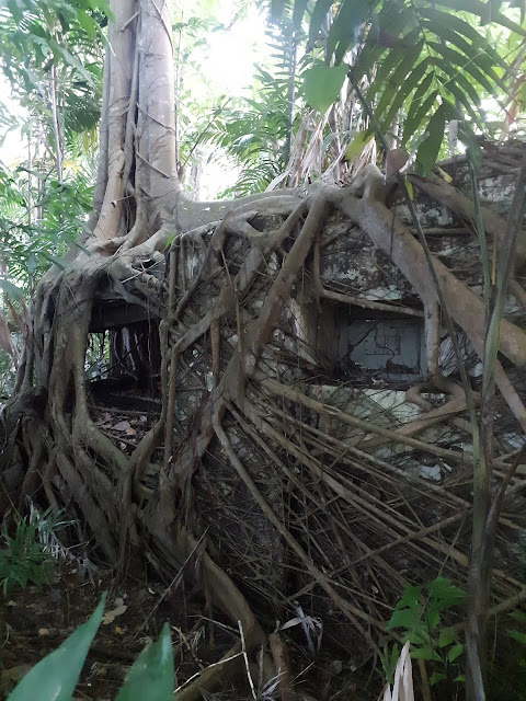
Circumventing the tree branch, I continued on the track which bends sharply to the left, goes up a slope, and I found myself in front of the tower that marks the summit...

The vegetation surrounding the structure is pretty dense and it seems that there is no other way up to here. I went down the same way I came up and continued on my sightseeing about Bermuda.
Just in case you want to also bag the second highest point of Bermuda...
Gibbs Hill, at 75 m, sits further south on the island. This hill is much more accessible, and with a lighthouse on the top of the hill, is a real tourist destination.

You can get to the top of the lighthouse which offers a splendid view over much of Bermuda.

Great post. We will go there.
ReplyDeleteThanks for this detailed account! It sounds like there's really no good viewing point from the summit of Town Hill, too bad.
ReplyDeleteThe lighthouse on Gibb's Hill probably has much better views.