Some mountain hikes in South South Korea
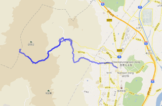
Godangbong, Geumjeongsan. Busan, South Korea
Date: 12th Feb. 2012
Summit: 801.5m
Trailhead altitude: ~85m
Distance, one way: ~6.7km
The peak was very crowded was a menagerie of pple, fighting to get a shot with the summit marker.The weather was great, and it as a great day out, despite the tiredness from a red-eye flight into Busan. I went down fast, took a bus from the temple, and before long was having a satisfying meal of hot broth with oyster and rice, by the bus terminal, near the Beomeosa metro stop.
Chibulbong & Sangwangbong, Gayasan, Sobaek Mountain Range. Gayasan N.P., South Korea
Date: 17th Feb. 2012
Summit: 1433m & 1430m
Trailhead altitude: ~630m
Distance, up and back: ~8.8km
Date: 12th Feb. 2012
Summit: 801.5m
Trailhead altitude: ~85m
Distance, one way: ~6.7km
From my conference hotel at Haeumdae, I took the metro to Beomeosa station. It was Sunday, and despite the winter cold, the city folks were out in full force with trekking poles, and full hiker’s order. From Beomeosa station, I headed uphill towards the temple, by a mixture of roads and trails. After the temple sightseeing, I discovered that at the temple's back exit, a trail leads up to Geumjeongsan’s tallest peak, Godangbong, at 801.5m. The trail was pretty crowded. The trail is easy and leads up to the North gate of GeumJeongsan fortress. There, hundreds of hikers basked in the winter sun, having their sunday hike-out picnic. The picnics were not simple sandwich and cheese kind, as some hikers had their cooking and barbecue equipment out. From here, it was 20min more before the summit was reached.
Chibulbong & Sangwangbong, Gayasan, Sobaek Mountain Range. Gayasan N.P., South Korea
Date: 17th Feb. 2012
Summit: 1433m & 1430m
Trailhead altitude: ~630m
Distance, up and back: ~8.8km
After Breakfast at the Haeinsa temple at 6:10am, I started hiking 6:50am. It was snowing ever so gently on the way up. The trail was was not too steep and with constant gradient up till the ridge where the rocky summit portion begins. By now, although the snow has stopped, the trail was snow covered. The snow was slippery at the higher reaches, and I have to plan my line of approach carefully. A crampon would have been useful at some parts. Finally reached the summit of Gayasan, Chilbulbong (1433m) at about 910am. Then descended and went up the nearby, more trodden summit Sangwangbong (1430m). The sky was clear, and the wind chilling to the bone. The cold, ice and snow made the summit feels much higher than the 1433 meters altitude. The temperature must be about minus 10C, as water in my bottle that was placed in my bag started to freeze. I started down 930am. The descend was not easy, as what was snow has become wet and revealed the ice that was underneath. It was a slippery descend and I fell numerous times. The trail was deserted, and despite the cold, the lonesome serenity was magical. Perhaps the night spent in Haeinsa had calmed the soul somewhat. It was not until I am down from the summit block, and almost on the downward way on the wooded ridge that I met some other souls, a pair of monks. All in all I met about eight people. I reached back to the temple at 1110am for a hearty vegetarian lunch.


Comments
Post a Comment