Kékes, Hungary, 1014 m
Route: Veronika-rét ski slope
Starting elevation: 770 m
Elevation gain: +245 m
Hike distance (one way): 1.9 km
Click here for GPS track
Hungary, dominated by the Great Hungarian Plain is a pretty flat country except for the northern parts near the border with Slovakia. The highest bit of this area is the Mátra mountains, capped by Kékes, which in Hungarian means "bluish".
Kékes is about 100 km away from Budapest, and the nearest large town/city to Kékes is Gyöngyös. I had spent the previous at the Hungary-Slovakia border town of Balassagyarmat and had visited the quaint little village of Hollókő (A world heritage site, well worth the visit) in the morning, before heading towards Kékes.
One can drive all the way to the summit, but it is more interesting to make a small hike out of the whole visit. I parked at a make-shift car park at the base of a long ski-slope, named Veronika rét and proceeded to walk up the ski slope whose top end is the summit.
It was late autumn, and the weather had slightly cleared up since morning. The slope was quite gentle, and soon the TV tower at the summit appeared and loomed large in the background. The crowd also started to thicken. It was a Saturday and Kékes is a very popular place for Hungarians trying to make the best out of the remaining autumn days before winter sets in. Families, with prams and old folks, groups of young people horse playing along the way, friends deep in conversations, and couples hand in hand... it was a delightful walk.
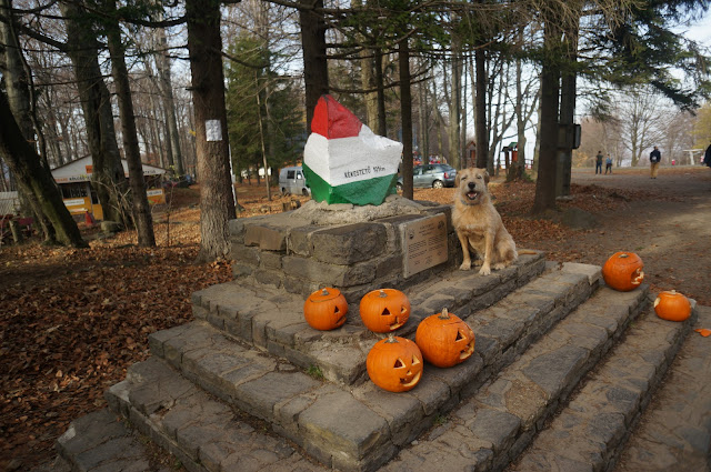
The summit is well developed with several restaurants, and souvenir shops. The summit marker sits on a stepped pedestal and people queued up patiently to take photos of themselves with the summit marker.
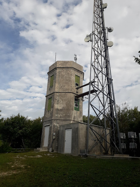
The marker is rather overshadowed by the TV tower complexes just next to it. In fact within the fenced up compound of the old TV tower, there seems to be a small bump which is higher than the summit marker (not counting the buildings and radio tower in the vicinity). However, It looks a bit artificial and my guess is that it is some sort of a bunker.
For 400HUF, I took an elevator up a few levels in the 'new' TV tower for a better look over the surroundings of Kékes.
I descended from the summit back to my rented car, drove to Gyöngyös for a nice late lunch, before driving to Budapest Airport to catch a evening plane home...
Hungary, dominated by the Great Hungarian Plain is a pretty flat country except for the northern parts near the border with Slovakia. The highest bit of this area is the Mátra mountains, capped by Kékes, which in Hungarian means "bluish".
Kékes is about 100 km away from Budapest, and the nearest large town/city to Kékes is Gyöngyös. I had spent the previous at the Hungary-Slovakia border town of Balassagyarmat and had visited the quaint little village of Hollókő (A world heritage site, well worth the visit) in the morning, before heading towards Kékes.
 |
| View of the Kékes, from the road towards Gyöngyös. |
One can drive all the way to the summit, but it is more interesting to make a small hike out of the whole visit. I parked at a make-shift car park at the base of a long ski-slope, named Veronika rét and proceeded to walk up the ski slope whose top end is the summit.
It was late autumn, and the weather had slightly cleared up since morning. The slope was quite gentle, and soon the TV tower at the summit appeared and loomed large in the background. The crowd also started to thicken. It was a Saturday and Kékes is a very popular place for Hungarians trying to make the best out of the remaining autumn days before winter sets in. Families, with prams and old folks, groups of young people horse playing along the way, friends deep in conversations, and couples hand in hand... it was a delightful walk.
The summit is well developed with several restaurants, and souvenir shops. The summit marker sits on a stepped pedestal and people queued up patiently to take photos of themselves with the summit marker.
The marker is rather overshadowed by the TV tower complexes just next to it. In fact within the fenced up compound of the old TV tower, there seems to be a small bump which is higher than the summit marker (not counting the buildings and radio tower in the vicinity). However, It looks a bit artificial and my guess is that it is some sort of a bunker.
 |
| The slight 'bump' within the cordoned off area of the old TV tower which is higher than the summit marker location where i took the photo from. |
 |
| The 'new' TV tower originally built in 1981 and since improved and expanded. |
 |
| View from the look-out platform of the 'new' TV tower. |
 |
| View of the 'old' TV tower, built in 1958. |


Comments
Post a Comment