Impalila Island... a very short visit to Namibia
 |
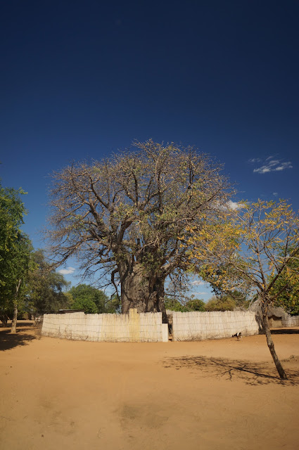
| The big baobab tree in Kafubu village, Impalila, Namibia |
Date of Visit: 28th May 2019.
Impalila Island is right at the eastern tip of the curious geo-political artefact known as Caprivi Strip in Namibia. Impalila island is wedged at the confluence between the Chobe and Zambezi rivers, thus seemingly splitting Zambia from Botswana. This is the shortest visit to any countries that I have ever made, as I don't usually do a quickie stamp-and-go visits to countries. I made this visit while staying near Kasane, Botswana.
Bonnie,, my host at the place that I stayed at, arranged for the tour. We started off from a jetty behind the SPAR supermarket in Kasane, We got into a small boat and the first stop was to clear the Botswanan immigrations, in a small house slightly upriver.
 |
| The Botswana border post, by the Chobe River. |
 |
| The jetty at the Botswana border post, the Chobe River. Namibia is just across the river. |
It seems the immigration rules are not much enforced for the locals here, as I noticed that both Bonnie and the boat operator didn't even bother to clear immigrations (both of them are from Botswana). After the stamping of my passport, I proceeded back to the boat. A a pleasant breezy 10 minutes boat ride down river brought us to the landing point for Impalila Island.
 |
| The landing point of Impalila Island |
The area is part of the Impalila Conservancy, so there are limited development and the whole place still retains a very rural feel. We first have to register at the Conservancy office, which is a zinc plate shack near the landing point. There, we met up with Mike, my assigned guide. We then proceed on to the Namibian immigration post, which was in a well-built brick house. To save us some time, the immigration officer simply gave me both the entrance and exit visa stamp, so that I don't have to stop by on the way out.
 |
| Wefie with Mike, my guide on Impalila Island. |
We then walked across some fields toward Kafubu (which sounded to me like 'Kavuvu'), the main village on Impalila island. Impalila.island is about 72 km in area, bounded by the Zambezi river from the north, Chobe River from the south and some minor meandering floodplain rivers from the West. The island has a population of about 2000 people, living in 43 villages, of which Kafubu is the largest one. Mike's home is in a village about 8 km away. The people on Impalila Island speaks the Subiya language, which is from the Bantu language family. The tribal structure is still very much in place here, as Mike mentioned that any major decisions, such as allocation of land is still ultimately made by the tribal chief.
We walked around Kafubu with Mike explaining the politics and culture of the area. Most of the houses in the village are made of mud and thatch. There are only a couple of houses that are made of bricks. One belongs to an ex-ambassador who decided to move back to his hometown on Impalila island, and the other belongs to the medicine man.
 |
| The houses in Kavuvu village |
The village of Kavuvu is dominated by a large Baobab tree. It is surrounded by a reed fence, and local womensell their craft materials, such as woven baskets and wood carvings there.
 |
| The large Baobab tree (probably of the Adansonia kilima sp.) that dominates the village of Kafubu, with Mike standing in front of it. |
 |
| Chobe River. View from near Kafubu. |
Afterwhich, it was back to the boat, and back to Kasane, Botswana. The whole trip lasted about an hour and a half.


Comments
Post a Comment