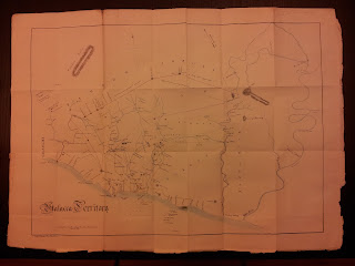
1856 Map of Malacca's Territory
This map is an attachment to the 1856 issue of the Journal of the Indian Archipelago and Eastern Asia (JIAEA). At that time, the Indian Archipelago refers to what is today the islands of Indonesia, as well as the Malay Peninsula and Borneo. This map was 'submitted' for publication by one Thomas Braddell. We today, of course, know of Braddell by the local places named after him, Braddell Heights, Braddell MRT station...e.t.c... Braddell was the first Attorney General of the Straits Settlements in 1867. Having spent the bulk of his career in the Straits Settlements, as employee of a sugar estate in Penang, then an official with the East India Company, he was intensely interested in the Malay region, and contributed a lot of articles to the JIAEA. Braddell is a self made man along the line of Stamford Raffles. From humble origin, he became successful through drive and talent.
According to the article that accompanied this map, the map here was made for Braddell by Mr. Valborg, a surveyor in Malacca. The map shows the extent of Malacca's territory, with boundaries with the surrounding Malay staes, as interpreted by the map maker. It shows well known features like Mt. Ophir, Muar river...etc... Apparently, this was the most accurate map of Malacca at that time, and it predates any British government maps of Malacca (At that time, Malacca was part of the straits settlements, that was administered by the East India Company, based in Calcutta).


Comments
Post a Comment